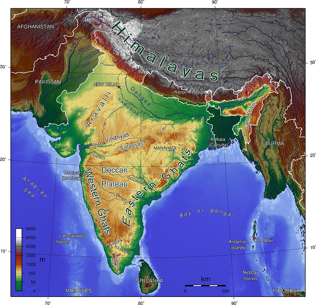
central Highlands Peninsular plateau
# central highlands
1. Arawali :-
*it extends from Palampur (Gujarat) to Delhi.
*it's total length is 800 km.
*it is one of the oldest fold mountains of the world.
*Both height and width of Aravali decrease as the move from South to North.
* guru Shikhar is the highest peak of Aravali.
*Mt. Abu is the tourist destination place and Jain based religious center (Dilwara temple located in Mt. Abu).
*Arawali is a perfect water divide ie., no river water crosses the Aravali range from one side to another.
*there are three geographical structure in India which are considered as perfect water divide
1.arawali 2.vindhyachal 3.westeren ghats
/Aravali
- - - - - - - - - - -vindhyachal
\westeren ghats
*entire Aravali region is rich in non-ferrous (copper, zinc, lead, aluminum). Khetri mine in Rajasthan is the most important mine of India and is known as the copper capital of India.
*Zawar mine:- ZAWAR MINE in Rajasthan is an important mine for lead and zinc.
2. MALWA PLATUE (M. P.) :-
*length of MALWA platue is 560 m and width is 390 kms. it is bordered by arawali in North, vindhyachal in South and Bundelkhand in the east.
* Sediment deposition is found in Peninsular India.
(nowhere in Peninsular India Sediment deposition is found).
*MALWA place is considered as a badland topography (no forest) during ☔ the rainy season the upper section of MALWA plateau is completely dissected. gully formation is taken place. no forest and no agriculture is there.
* law and order is a issue in this region. this region is known for dacoits.
* four right bent tributaries of Yamuna river flows in this region they are a chamber, beta, Sindh and Ken(West to east).
3.VINDHYACHAL:-
* vindhyachal extends from joban (Madhya Pradesh) to Shasha ram (Bihar).
*it's total length is 1050kms.
*MAIKAL RANGE is a connecting link between Satpura and vindhyachal.
*vindhyachal is a perfect water divide. in fact, vindhyachal is a perfect water divide in respect of cultural, tradition, law and order, good habits, etc.
4.CHOTANAGPUR PLATUE:-
*Hazari bagh and Ramgarh hills are the part of Chota Nagpur plateau and raj mahal hills are the extension of Chota Nagpur plateau.
*highest peak of Chota Nagpur plateau is parasnath.
*almost every kind of mineral is found in this region. Globally no region has the richness of all the minerals as Chota Nagpur plateau.
*Damodar river is found in this region. DAMODAR is a tributary of Hugli and Hugli is a distributary of river Ganga. {Damodar is known as Sorrow of bengal} because of the frequent flood.
|
|ganga
¥
|
Damodar ~~~ ~~~~
|
¥ Hugli
¥
*DAMODAR Valley Corporation (DVC) happens to be the first multipurpose river valley corporation of the country established in 1948. this project is based on tenessy Valley of USA. Multipurpose river Valley has different aims like:-
# electricity generation
#irrigation
# availability of drinking water
# controlling the flood.
# development of the region.
*Bhilai, bukaro, durgapur steel mines were established in this region after independence.
% BHILAI AND BUKARO WERE DEVELOPED WITH RUSSIAN COLLABORATION.
%RAULKHEDA WITH GERMAN COLLABORATION.
%DURGAPUR STEEL MINE WITH BRITISH COLLABORATION.
# Iron ore mines of this region are:-
1.namundi(jharkhand).
2.gurumunshi(oddisa).
3.kirigura(jharkhand).
4.sundarban(orrisa).
#coal mines :-
*jhariya (jharkhand).
*raniganjh(west bengal).
*asansol(west Bengal).
#coal head uarter of india is in asansol.
#shilong platue:-(meghalaya)
*Shillong platue is separated by Peninsular platue through rajmahal hills. It consist of three hills garo, khasi and jayantia. Mikhile hills is the highest peak of Shillong. The highest peak of Peninsular India also.
*shillong platue receives highest rainfall almost 280+cm.
*Cherapunji recieves highest rainfall in 24 hours.
*mawsamgram is the wettest place of india because it recieves highest average rainfall. *this region is known for ☕ tea plantation.
#vidharb region is demanding for separate state with nagpur as capital.
#tea from taiwan is the best quality in the world and india is the largest producer and consumer of tea in the world.
PENINSULAR PLATUE :-
1.SATPURA RANGE :-
* satpura lies in the south of vindhyachal. its a discontinuous mountain chain. Its total length is 900kms and average elevation is 770m.
*Narmada flows through a rift Valley b/w vindhyachal and satpura. Satpura consist of a following hills (west to east) rajpeepla(maharashtra), gwaligarh, mahadeo, maikal. This region is thickly forested.
*rajpeea and gwaligarh are separated by a gap known as khandwa.
*dhoopgarh is the highest peak of satpura range. Located in mahadeo hills.
*panchmadi is the only hillstation in central India.
*ujjain and indore is located in this region.
*indore is known as twin city of india and ujjain is known for lord mahakaleshwara.
Deccan plate :-
*it consists of following ranges (South to north)
Harish chandra
Balaghat
Satmala
Ajanta
Gawaligarh
*Katiyawar Peninsula is extension of deccan platue.
*deccan platue is a result of larva formation, black soil is found in this region. Black soil has high water retention quality and also known as regur soil.
*black soil is known for cotton production, red soil also known as cotton soil.
# black soil is also used for the production of sugarcane and tobacco.
# rajmundri in andrapradesh is known for world's best quality tobacco.
# KARNATAKA PLATUE :-
1. THE whole region is covered with red and yellow soil.
2. This region is rich in ferrous materials.
3. Kudermukh mine near baba Budan Hills. This plain is known for iron ore.
4. Both side of karnataka platue is a plain region. Western plane is known as mannar and Eastern is maidan.
# Telangana platue :-
Two important rivers are flowing in this region Krishna and godawari.
Northern part of Krishna is known as Telangana and southern part is known as rail seema.
Coastal region coastal Andra. This region is rich in coal and almost 20% of total Indian coal is from Telangana.
# westeren ghats :-
1. Westeren ghat is a continuous mountain chain runs parallel to west coast.
2. Westeren ghat is also known as Sahyadri.
3. Its total length is 1600km with average width of 100km and average elevation 1000m.
4 . It extends from tapi in north to kanyakumari in south. (gujrat,maharashtra,tamil nadu,kerela)
5 . Western ghat is a perfect water devide.
6. Western side of western ghats is highly disected due to seasonal rivers in monsoonal season.
7 . Western side of western ghat is thickly forested.
#kodai canal is an important hill station at tamil nadu in palani hills.
#munnar and thikadi are two important hill stations of kerela and anaimalai and cardamam hill respectively.
*important ghats
Palghat - (palakkad and coimbatore)
shenkotta - (kollam and madurai)
thalghat- (mumbai to nasik)
bhorghat-(mumbai to pune)
lonawala and khandala are the two important hill stations b/w Mumbai and pune.
#Eastern ghat -
*its a set of discontinuous mountain chain, running parallel to east coast.
* average elevation 1100m.
*its a type of fold mountain.
*it receives less rainfall as compared to western ghats.
* it consist of following ranges -north to south
northern sarkars(oddisa in andra Pradesh)
nallamalla in andra
Velikonda In andra
Pelikonda in andra
Jawedi and sheveroy in tamil nadu.
#Highest peak Of eastern ghat is mahendra giri in oddisa.
As we move from north to south hight of easteren ghat decreases . Hight of westeren ghat decreases as we move from south to north.


Comments