Comparative Analysis of Past Delimitation Exercises & Their Impact on Governance

Image
                          Comparative Analysis  Delimitation is the process of redrawing the boundaries of electoral constituencies to ensure fair representation based on population changes . In India, it is conducted by the Delimitation Commission , an independent body established under Article 82 (for Lok Sabha) and Article 170 (for State Assemblies) after every Census . Key Objectives of Delimitation ✔ Equal Representation – Ensures constituencies have uniform voter strength , preventing overrepresentation or underrepresentation.  ✔ Electoral Integrity – Adjusts boundaries to reflect demographic shifts , maintaining fair political representation .  ✔ Reservation Adjustments – Determines SC/ST reserved seats based on population distribution. Historical Timeline of Delimitation in India 📌 1952 – First delimitation based on the  1951 Census .  📌 1963 – Adjustments after state reorga...

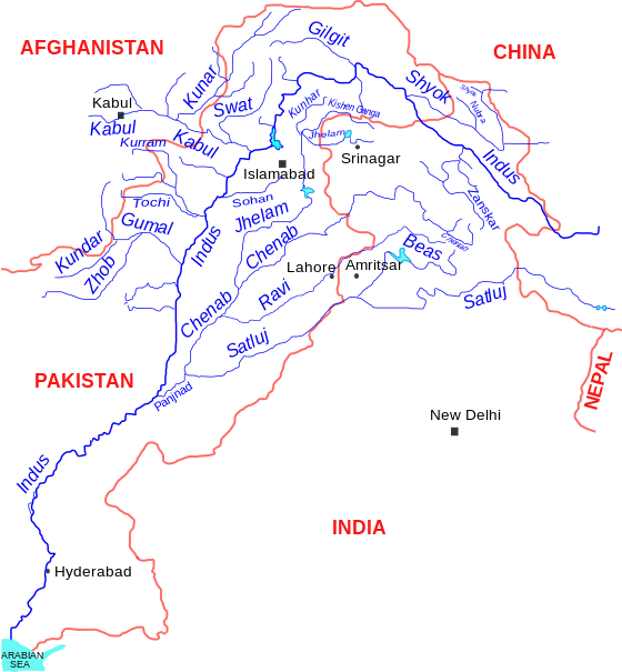
🚩Indus Water Treaty of 19 sep 1960🚩

🚩Indus water treaty 1960🚩

image source:- wikipedia

👉 It is a water sharing pact between India-Pakistan which was signed in sep 19,1960 brokered by the World Bank.
👉The treaty aimed at the satisfactory utilization of water flow of Indus and its tributaries (Ravi,beas,satluj,jhelam and chenab).
👉Indus(Sindhu)is a transboundary  river of Asia and trans- himalayan river from the source of Mansarover lake . originates from north east of mount Kailash in westeren tibbet. It bends around the Naga Parbat massif,and flows by south to south-west through Pakistan before entering into the Arabian sea near the port city of Karachi.
👉States of provience - Tibattian autonomous region,Gilgit-Baltistan,Khyber paas,Pakhtoonkhawa,Punjab and sindh.
👉This treaty gives the control over the water of three 📍"easteren rivers"

📌Beas(Rohtang la),
📌Ravi(bara bangal,branch of dhauladhar )and 
📌satluj (Rakshas tal lake near mansarover and mt. Kailash)with 41 billion m3 of annual water flow to India . 

📍the "three westeren" rivers 
📌Indus (mansarover lake,tibattian region),
📌Chenab(baralacha la himachal pradesh)and 
📌Jhelam also known as vitasta  (Pir panjal range)with a mean annual flow of water 99 billion m3- to pakistan.

⛔treaty provisions
1. According to A-1 of IWT any river or its tributaries and its catchment area which are not a part of these 5 rivers is a part of Indus river system including creeks,delta channel and connecting lakes.
👉The treaty allocates the easteren river system as an exclusive use status for India after the permitted water use of Pakistan.similarly westeren after uses permission of India.
💡Dams constructed after the mutual agreement- Salal dam(Hydro electric Power station)is the run-of-the-river hydropower project on chenab river in Reasi district of J and K.1st hydropower project by India under Indus-water-treaty completed in 1987.{currently run at 57% capacity factor}.
👉Cases of Dispute-Permanent court of arbitration(PCA).

🚩Result- 
The treaty resulted in partitioning Of the river rather than sharing .

Comments

Popular posts from this blog

Is the Sanctity of Parliamentary Debate, Which Lies at the Core of Democratic Decision-Making, Being Compromised?

‘India had parliamentary institutions when people of Europe were mere nomads’

Salary, Allowances, and Pension of Members of Parliament Act, 1954